
news
28.11.2023
New GRANT NCN in Our Department !
We are pleased to announce that Dr. Artur Guzy has received a grant entitled "3MAP: Monitoring, Modelling
and Mitigation of land subsidence in delta areas" funded by the NCN National Science Centre as part of
the OPUS 25 call.
The grant amount awarded is PLN 1,165,344 (approx. EUR 230,032).
The 3MAP project concerns land subsidence in delta areas, a global issue mainly caused by excessive groundwater
extraction and sea level rise (SLR). Land subsidence is particularly important in delta areas due to their low
elevation, dense population, and economic significance. Despite climate changes, a significant factor in SLR,
a considerable part of the currently observed, so-called relative SLR (rSLR), results from accelerated land s
ubsidence due to excessive groundwater use. This leads to increased flood risk, infrastructure damage, saltwater
intrusion, and ecosystem disruption. Many large urban centers, including New Orleans, Dhaka, Bangkok, Manila,
Ho Chi Minh City, and Jakarta, illustrate the scale and intensity of this problem.
Within the project, mechanisms of land subsidence will be investigated, methods of monitoring and modeling will
be developed, and strategies to minimize the effects of this phenomenon will be formulated. Using InSAR, for the first time,
a full three-dimensional field of land displacement will be determined, coupled with a three-dimensional numerical model
of the compaction of the aquifer system. Such an approach will allow for a holistic examination of the interactions
of processes leading to land subsidence.
The project's results will provide concrete findings and scientific recommendations that will help take action to reduce
groundwater exploitation and minimize the potential negative effects of land subsidence in the coming decades.
The research will be conducted in the Mekong Delta area in Vietnam. The project will be carried out in the years 2024-2027
at the Faculty of Geo-Data Science, Geodesy and Environmental Engineering of AGH University of Krakow, Poland (Land Subsidence
and Hazard Mitigation Research Group) in collaboration with research teams from the Universit? degli Studi di Padova
in Italy (Prof. Pietro Teatini), the Wageningen University & Research in the Netherlands (Dr. Philip Minderhoud),
and scientists representing the University of Ho Chi Minh in Vietnam.
Full project description: [PDF].
OPUS is a well-known competition among scientists in Poland organized by the National Science Center, enabling the
implementation of basic research in Polish units. OPUS grants allow the realization of multi-year complex projects,
building large scientific teams, using large international research facilities, and cooperating with foreign partners,
all irrespective of the career stage of the project leader.
Congratulations!
Administrator
11.11.2023
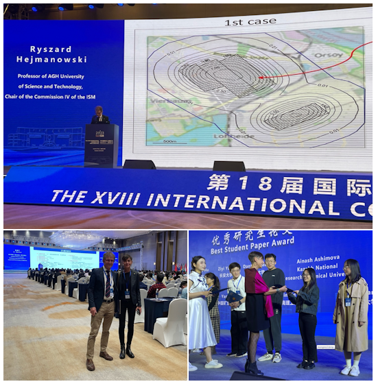
The 18th world congress of the International Society for Mine Surveying (ISM)
The 18th world congress of the International Society for Mine Surveying
(ISM - www.ism-minesurveying.com)
was held in Beijing and Xuzhou on 26-29.10.2023. Representatives of our Faculty took part in the congress
and ISM presidium meetings. Prof. Ryszard Hejmanowski, chairman of the 4th ISM Commission, was invited
to deliver a Key Note in the plenary session. During the congress, a number of scientific sessions were
held in the fields of geodesy, remote sensing, mining surveying. Among others, papers and presentations
by young scientists were evaluated, in the evaluation of which Prof Agnieszka Malinowska - Poland's
delegate to the ISM - took part.
The ISM is a non-profit association with dozens of national organisations from all over the world.
The Polish Committee of the ISM is also one of the founding members
(www.pk-ism.org ).
On behalf of the Polish ISM Committee, Wojtek Skoblinski, engineer, also took part in the congress.
The congress concluded with a visit to CHCN AV, Shanghai.
Webmaster
20.03.2023
International project Open SAR Library EXPRO+ (AlignSAR)
Open SAR Library - EXPRO+ (AlignSAR) is an initiative funded by the European Space Agency.
The AlignSAR project aims to (1) define a procedure for creating benchmark SAR datasets for machine
learning applications, (2) develop a quality-controlled, documented, open database of spatial
and temporal SAR signatures for real-world objects, and (3) create a database that respects
FAIR and Open Science principles.
The AlignSAR project is led by the University of Twente in the Netherlands. The consortium also
includes: University of Leeds from the UK, AGH University of Science and Technology from Poland,
and RHEA Group from Italy.
The project began in February 2023 and is expected to end in February 2024. More information
about the project can be found at
www.alignsar.nl.
Webmaster
18.05.2022
Scientific seminar of Visiting Professor Pietro Teatini
On 12th May 2022, there was a scientific seminar at the Faculty of Geo-Data Science, Geodesy,
and Environmental Engineering, during which Visiting Professor Pietro Teatini presented
a short lecture titled 'Advanced 3D continuous and discontinuous geomechanical modelling
of stress and deformation fields due to subsurface fluid withdrawal and injection'.
Pietro Teatini is a professor in Hydrology and Hydraulic Engineering at the Department
of Civil, Environmental and Architectural Engineering, University of Padova, Italy.
The main topic of the meeting was the modelling of surface movements of discontinuous
deformation caused by fluid withdrawal and injection. The Professor showed that basic modelling
techniques are focused mainly on vertical movements and quite often they do not consider the
existence of faults of earth fissures. In a presented advanced approach, it is possible to include
discontinuous deformations and model both, the vertical and horizontal displacements, which are
important considering local people and infrastructure. Professor Teatini also presented 3 case
studies, where the advanced methodology of geomechanical modelling was applied, which were
located in China, the Netherlands and the USA. Each case study was focused on a different
aspect of modelling, addressing the following issues: fissures modelling, threats connected
with faults reactivation including induced seismicity and modelling of horizontal displacements.
The seminar ended with a short discussion about deformation caused by fluid withdrawal and injection,
approaches to their modelling and problems connected with this topic
Photogallery
)
)
)
)
Webmaster
20.11.2021
Research internship at the University of Aberdeen Artur Guzy, M.Sc., Eng and Wojciech Witkowski, Ph.D., Eng.
In October 2021 Artur Guzy, M.Sc., Eng. (Ph.D. Student of the Department of Mining Areas Protection,
Geoinformatics and Mining Surveying and Wojciech Witkowski, Ph.D., Eng. (assistant professor of the Department
of Mining Areas Protection, Geoinformatics and Mining Surveying) held their research internship at the Uniwersity
of Aberdeen (Great Britain), where the third member of their joint project Andrés González Quirós, Ph.D., works.
The theme of the internship was directly connected with the grant of the European Space Agency: Application of InSAR
to Model Compaction of the Aquifer System and Movement of the Land Surface in Abandoned Mines
(Cosmo-SkyMed Project no. 65954), the head of which is Artur Guzy, M.Sc., Eng.
The degradation of rock mass and the occurrence of land subsidence or even sinkholes is one
of the negative effects of underground mining. Such phenomena could damage infrastructure
and threaten residents of altered regions. However, underground mining typically requires
deep drainage of rock layers via pumping. The original hydrogeological conditions
of the rock mass are therefore affected. As a result, due to the change in the groundwater
levels and the decrease in the hydrostatic pressure, the aquifer system is depleted
and rock mass is additionally compacted. However, with the closure of the mine by flooding,
the aquifer system is beginning to be restored. The rock mass is re-filled with groundwater
as a result, and uplifts occur on the land surface. However, the fluctuation and rapid flow
of groundwater related to the flooding of the mine can also lead to rock mass suffocation
nd the formation of sinkholes.
Hard coal mining in Europe has a long tradition and goes back to the beginning of the industrial
revolution. Coal mines were mainly located in the United Kingdom, Germany, Belgium,
the Netherlands and Spain. Hard coal is still being mined in Poland.

Webmaster
20.01.2017
Study Geoinformation and Mining Surveying registration is now opened